 The facts are startling. More than 2 billion people (CDC, 2015) worldwide suffer from micronutrient deficiency – 795 million (FAO, 2015) of whom are undernourished. The challenge to nutritiously and securely feed the growing population is further exacerbated by climate change which has led to extreme weather patterns and decreasing crop yields. With more than 10% of the world’s population living on less than US$1.90 per day (World Bank, 2016), the imperative to transform food systems in a way that simultaneously improves lives, livelihoods and the condition of natural resources is clear.
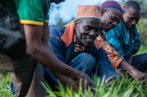
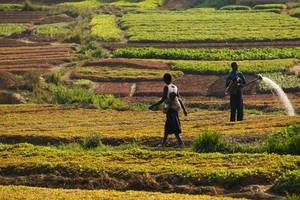
Climate change presents a formidable challenge as one of the biggest constraints to improving food systems, food security and poverty alleviation around the world, especially for the world’s most vulnerable people. The impacts of climate change and poverty are closely interconnected (Bager, CCAFS) as climate change impacts land availability, rainfall, and disease. With poor people disproportionately dependent on rainfed agriculture for their livelihoods, these communities are thus especially vulnerable to the impacts of climate change. The increasing frequency and intensity of climatic shocks impinges on their ability to sell an agricultural surplus, meaning less reinvestment in their farms and other livelihood activities, and less ability to purchase a nourishing diet.
The breakthrough Paris Climate Agreement of 2015, while far from perfect, represented an historic and ambitious new phase for climate action, and opened a door for the agricultural sector to take a leading role.
“We recognize that the agricultural sector has a key role to play in increasing resilience to climate shocks. Food security, food production, human rights, gender, ecosystems and biodiversity were all explicitly recognized in the Paris agreement and these are issues at the core of our work,” according to Elwyn Grainger-Jones, Executive Director of the CGIAR System Organization.
Across Africa, Asia and Latin America, CGIAR and its partners are developing climate-smart technologies to help farmers adapt to climate change as well as mitigate agriculture’s contribution to climate change. The CGIAR Research Program on Climate Change, Agriculture and Food Security (CCAFS) brings together the expertise in agricultural, environmental and social sciences to identify and address this nexus between agriculture and climate change. Innovations such as drought tolerant crops, agricultural insurance schemes and management practices for reducing greenhouse gas emissions are just a few of the technologies being developed by CGIAR.
Originally published on the CGIAR website.
Click here for the full story

 Food and Agriculture Organization (FAO) recently launched the Water Productivity Open Access Portal (WaPOR) to monitor and report on agriculture water productivity over Africa and the Near East.
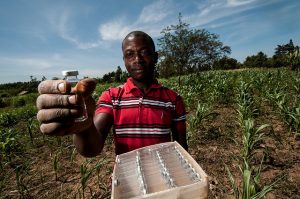 “We’re at the forefront of understanding how we can make the most of soils to
 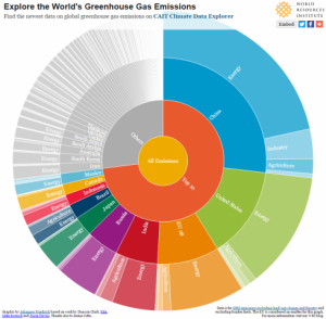 A lot has happened since countries met in Paris in 2015 and agreed on an accord to combat climate change. So far, more than
 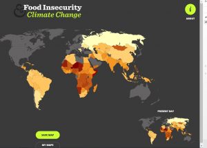 The
The  Deforestation